Infrastructure in the AACHD


Data-driven insights into housing conditions, population change, and development pressures shaping the district today and what they mean for affordability, stability, and cultural preservation.

Overview

This section reviews the physical environment of the African American Cultural Heritage District, including its parks and open spaces, transportation systems, and public realm. Together, these elements shape daily life and community identity—providing opportunities for gathering and mobility, while also revealing gaps in accessibility, shade, safety, and overall quality. The data highlights both the assets that anchor the district and the improvements needed to create a more connected, resilient, and welcoming environment.

Key Findings

The District is home to 11 parks and open spaces, including the Boggy Creek Greenbelt and Oakwood Cemetery.

The District is well-served by public transportation with access to the Red Line and various bus routes.

The public realm experience lacks consistent accessibility, natural infrastructure, and placemaking.

Open Space Programming

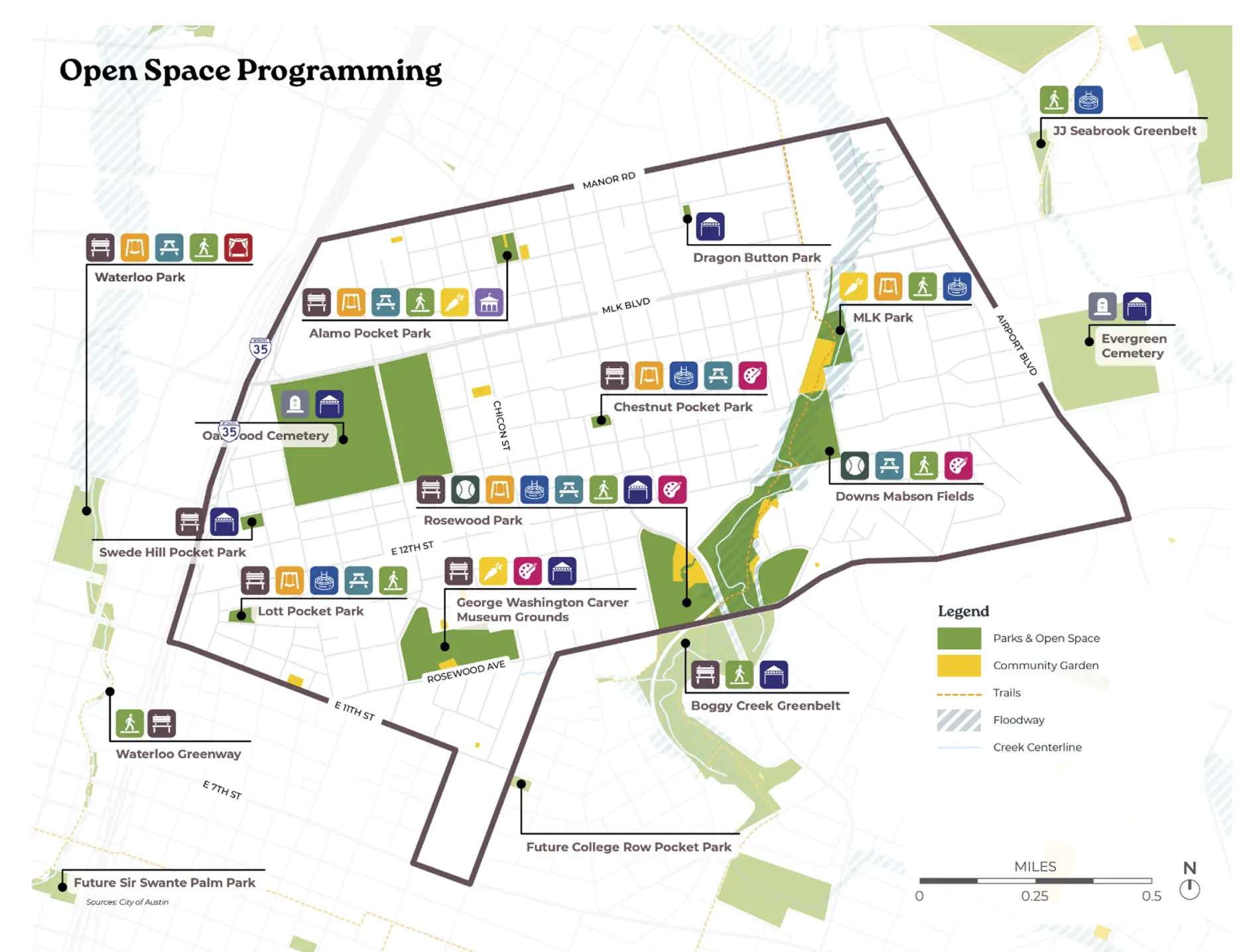
The District contains 11 parks and open spaces, including the Oakwood Cemetery and Boggy Creek Greenbelt. Small pocket parks, such as Lott Pocket Park and Alamo Pocket Park, offer gathering spaces and play areas. Other spaces, such as the George Washington Carver Museum Grounds, Rosewood Park, and Downs Fields, provide the historical context in addition to park amenities. With the Boggy Creek Greenbelt and trail providing north-south connections to other parts of Austin, the District lacks strong east-west connections to the Mueller Greenbelt, Waterloo Greenway, and other Downtown areas.

While many of these businesses are still around, a significant number of them have closed over the past several years as a result of declining revenue, rising rent, and the changing demographics of the neighborhood, where new residents don’t always value these important establishments in the same way East Austinites have in the past.

Transportation

The AACHD is well-connected by roadways, bus service, and Austin’s sole light rail line, the Red Line, providing multiple ways to travel in and around the District. Its proximity to I-35 and Airport Boulevard makes car travel convenient but also raises environmental and quality-of-life concerns. The planned  I-35 expansion  presents opportunities to improve safety at crossings, expand active transportation options, and add new green spaces in future phases. For bicyclists, on-street bike lanes run along major corridors and link to shared-use trails, while bike-sharing stations are available along 11th Street and Rosewood Avenue.

Bus Routes & 
Bus Stop Amenities

Bus routes run along the major corridors in the AACHD, with the MLK Station providing a key Red Line connection to Downtown Austin and beyond. Within the District, 108 bus stops offer varying levels of comfort and amenities. Over 30% of stops have no shade structure or benches, nearly 38% provide only benches, 30% offer both benches and shade, and just one stop has shade without a bench.

Public Realm Experience

The public realm in the AACHD varies widely in character and quality. Along commercial corridors such as 11th Street, 12th Street, and Manor Road, investments have been made in sidewalks, crosswalks, covered bus stops, lighting, district signage, and other amenities that improve pedestrian comfort. Yet, the quality of these improvements is inconsistent—from poorly placed streetlights to sidewalks in visible disrepair. In the residential parts of the district, many streets lack sidewalks altogether, while others only provide them on one side. Strengthening the public realm with consistent, high-quality improvements can encourage walking, support active transportation, and boost the economic vitality of local businesses.

Average Tree Density

The AACHD sits within one of Austin’s hotter, less-shaded areas, with tree canopy coverage ranging from just 10–30%. Research shows that canopy densities of 40% or more can noticeably reduce urban heat, with shaded areas often 5–10 degrees cooler than nearby sun-exposed streets.

The district’s limited tree cover reflects several factors: its location in the Northern Blackland Prairie ecoregion, historically defined by grasslands with scattered bottomland forests; past development patterns that deprioritized tree planting; and long-term disinvestment in street trees.

Even so, the historic residential areas and cemeteries contain some remarkable Post Oaks, Pecans, and Live Oaks–Living reminders of the area’s natural heritage and the importance of preserving and expanding tree canopy.

Help shape the future of our community through the AACHD Strategic Plan.